Photo courtesy of noaa.gov noaa.gov
New Year's Day snow a bust for Vail but looks promising this weekend
January 2, 2009 —
Well the New Year was rung in with a total bust weather-wise as a weak system on Thursday Jan. 1 weakened even more as it moved inland.
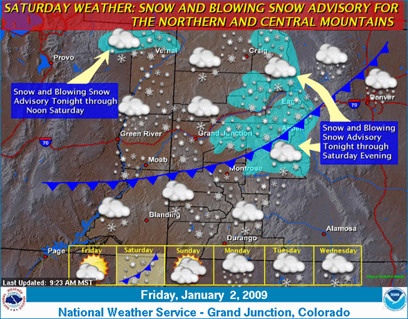
We do have a good shot of snow tonight (Jan. 2) and into Saturday Jan. 3 as this next Pacific system is stronger. A cold front will move through the northern and central mountains early Saturday as winds will increase out of the northwest.
Expect winds in the 15-25 mph range with gusts into the 50's above timberline. This storm is forecasted to drop anywhere from 4-8 inches by Saturday night, and temps will drop dramatically as the cold front moves through.
Saturday Jan. 3 looks to be cold with on mountain highs only in the teens and brisk winds. Pretty much the same forecast for the early part of the week. I believe snow totals with this storm will be relatively lower than forecasted (3-5 inches) as we are moisture limited, however, with high winds from the west/northwest snow will get blown around which will give us some pockets of good snow on the leeward side of Vail and Beaver Creek.
Our pattern for the next five days looks good as we should see storms move in every other day or so, we will watch.
Enjoy!
Weather: Friday, January 2, 2009
Temperature-40.7 degrees
Dew Point-21.0 degrees
Humidity-45%
Pressure-29.89 falling
Wind-N/NW 13 mph Gusts 25-30 mph
![]() 1 Comment on "New Year's Day snow a bust for Vail but looks promising this weekend"
1 Comment on "New Year's Day snow a bust for Vail but looks promising this weekend"
Sam — January 3, 2009
Reid:
This is you old buddy Sam from team Enviro and I will be out visiting Luke from Monday - Friday. I fully expect to see you and if you can spare a few turns with a midwesterner huffing an puffing from the air we should lay some tracks. Email is above and Luke has my #.
-Sam


