

Dan Davis trekkerphoto.com
- C4 Waterman takes stand-up paddling from surf to snow at Teva Mountain Games in Vail
- GNC Ultimate Mountain Challenge returns to Vail to test top Teva Games athletes
- Registration open for the 2010 Teva Mountain Games
- Vail Nordic Center will close for the season April 4
- Past Olympians, world champions team with celebs for Vail's Korbel American Ski Classic March 17-21
- Vail Valley Foundation looks to fund local competitors through Athlete Commission grants
- Mountain bikers, off-road enthusiasts rally against Hidden Gems wilderness proposal
- Free skating, Pazzo's pizza, hockey gear raffle Sept. 9 at Dobson Ice Arena in Vail
- Vail Resorts, Lindsey Vonn ink four-year sponsorship deal ahead of 2010 Olympics
- Armstrong, Ritter revving up talks to revive Coors Classic-style stage race
- All Real Sport Articles
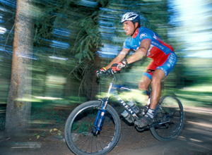
September 5, 2007 — Mountain biking is what you make of it: it can be relaxing or adventurous, casual or grueling. It all depends on where you go and what kind of trail you�re looking for. A lot of the terrain around Vail and the Vail Valley is steep, but mellow rides are out there. The following article gives three options for riders: from hard-boiled to over easy, these three rides are our recommendations for places to go to get your ride to order.
Trail #1: Over Easy
NAME: Vail South bike path
LENGTH: As you wish
HIGHEST ELEVATION: 8,150
ELEVATION GAIN: A few feet
DIFFICULTY: Easy
During summertime, riding up the gondola and mountain biking down is the most fun you can have without having to pump the pedals � unfortunately the Vail gondola shut down for the season on Sept. 3. (However, if you�re planning a vacation for next summer keep this ride in mind and visit these links:
Vail Mountain Safety Tips
Vail Summer Trail Map
Vail Mountain Mountain Biking Information
So what�s a take-�er-easy rider to do in the autumn, when the leaves are turning? Here�s a tip: most of the Valley�s aspen trees are on the north side of the valley (southern exposure), so ride on the south side of the valley (northern exposure) for the best possible view of autumn leaves.
How to get there: Park at the Vail or Lionshead parking structure and head south toward Vail Mountain (it doesn�t matter which street you choose, they all lead to the bike path!).
The ride:In no time at all you�ll come across the Vail Bike path and you�ll have to decide: East toward the Vail Golf Course, where waterfalls cascade down sheer cliffs high above the path; or West, through golden leaves which fall into the clear waters of Gore Creek by your side. Either way you go, you won�t run into anything too steep, too rough, or too tough � bring the kids and whomever else wants to come along.
Trail #2: Sunny-side up
NAME: Lost Lake
LENGTH: 12.7 Miles
HIGHEST ELEVATION: 10,248 ft
ELEVATION GAIN: 1,928 ft
DIFFICULTY: More difficult
This is simply a great ride which takes you through heavy timber, open meadows, around a mountain lake and over roads and single-track alike. Be prepared for an outdoor adventure on this one (bring your repair kit, windbreaker, etc.), but it�s not super-technical, so you don�t have to be an amazing rider or anything � you just have to be in fairly good health. To make it a bit easier run a shuttle and leave one car at the trailhead and one at the point where Lost Lake trail spills out onto Red Sandstone Road.
How to get there: Off 1-70, take Exit 176 for Vail. Turn to the north and proceed on North Frontage Road to Red Sandstone Road #700. Proceed up Road 0700 to the first right turn, which will be the Lost Lake 4WD Road. Park where available.
The ride: Ride up the 4WD road. Bear left at the #786 Road. Stay to the left at each of the other road junctions. There are blue markers along the way that will help you to stay on the right path. About 4 miles from the start of the 4WD road you will come upon the Lost Lake hiking trail. It is a single track and covers about one mile before it reaches the Lake.
Bike around the lake to the other side where the hiking trail picks up once again. It is a 3.4 mile ride out to the west trailhead. The trail ends at the Red Sandstone Road. When you get to the trailhead, take a left onto the Red Sandstone Road. Ride for about 4 miles back to the Lost Lake 4 WD Road where you began the ride.
Trail #3: Hard-Boiled
NAME: Meadow Mountain and Polly�s Plunge
LENGTH: As you wish (up to 12 miles)
HIGHEST ELEVATION: 9,500 ft
ELEVATION GAIN: 1,800 ft
DIFFICULTY: More difficult
If someone who likes to ride is looking for action, this is the right place to go � but that�s not to say you can�t back out if you find yourself bonking. The trailhead is easy to get to and there are options to get gutsy and go for a single-track spree, on the other hand the ride along an historic old Minturn road makes it one of those rides which can last as long (or as short) as the rider wants. Basically, it�s about having the options. It�s also a perfect autumn ride, when crisp autumn air brings a kind of refreshment found nowhere else.
How to get there: Turn off the Minturn exit from I-70 and go southeast on Highway 24 for 0.3 miles to the Minturn Forest Service Ranger Station where ample parking is available. From the trailhead sign, follow the old dirt road that winds behind the white house at the end of the parking lot. This road climbs gradually through large open meadows and Spruce-Fir forests. The open meadows are old sites of lettuce growing that occurred in the 1920's.
The ride: When you reach the fork in the road (2.7 miles) bear right along the road marked # 748. After a series of steep switchbacks you will enter an old clear-cut site, bear to the left here where the road continues upwards. Ride on the double track until you reach the Forrest Service hut. There is a single track trail on the east (right) side of the hut. The trail travels to the west past a small pond. After riding .3 miles from the hut, you will come upon an old fence. There is a trail that continues through the fence avoid this trail. The trail that you want is less obvious and follows the fence to the right. This single track descends through Aspen and Spruce-Fir woods.
This is where less ambitious riders should turn around and retrace their tracks. There are several tricky spots that you should be prepared for, so use caution. You will pass a beaver pond and then continue the descent to the rear of Battle Mountain High School. To complete the loop, take the side street back out to Hwy. 24. Take a right onto the Hwy. and ride about 3 miles back to the Meadow Mountain parking lot.
![]() Comment on "Autumn mountain biking in Vail" using the form below
Comment on "Autumn mountain biking in Vail" using the form below


